|
Lab Group: Rose Mayer and Mason Kirkpatrick Background The measuring of land use and cover change is a method that is common place in modern environmental practice. It is used to measure geographic change on the surface of the earth and more specifically how the use of certain areas has changed over time. The general motivation behind this lab in particular was to observe and assess the land use and cover change of the Lewis and Clark campus, surrounding neighborhoods and natural areas. Based off an aerial photograph of Lewis and Clark’s campus in 1939, our general goals for this lab were to gather data and photographs to use in comparison to the old photograph to generate qualitative results of the change in land use and cover. Rose and I chose to focus on the Estate Gardens of Lewis and Clark since it has been a heavily manicured area of the campus since its founding. By observing the change in land use and cover we can use the data we gather to more accurately observe change in The Estate Gardens. In general observing these types of change can provide details on how land use has changed and how that may impact surrounding environments. Procedure/Analysis First Rose and I chose the Estate Gardens of Lewis and Clark for the reasons stated above. Then using pins flags and our Garmin GPS we were able to map out a 90x90m square that encompassed the majority of the Estate Gardens. Next we were able to calculate the centroid of our square, a 30x30m area in which we marked the center with a pin flag. Lastly we setup our Kestrel Drop within our centroid. The following day we returned to our centroid to collect our gear, making sure to have left the Kestrel there for at least 24 hours. We synced the Kestral to our phones and recorded its data. Possible errors we may have encountered were, firstly our 90x90m square may not have been perfect due to the fact that our tape measurer only could reach 50m. This may have caused our measurements of 90m to be slightly off. Second, our 90x90m area was not perfectly homogenous due to the fact that in order to create a 90x90m area we were forced to traverse into the ravine a bit. This could muddle our observations slightly. Lastly, during the finals hours of collecting data our centroid was heavily trafficked by people because of the Pio Fair. This could lead to unnatural data being presented on the Kestrel during the final hours of collecting data. 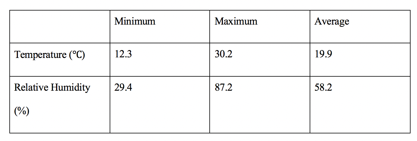 Location of centroid in Degrees: 45.45009 N, 122.66777 W
Centroid estimated error: 7.8 We found this data to be the quantitative results of our 24 hour observation of the Estate Gardens. Discussion Using both our qualitative and quantitative results in comparison to the 1939 photograph we were able to observe the general change over the past 79 years. The Estate Gardens have experienced minimal land use and cover change during this time mostly due to the fact that it had been a heavily manicured area for the college. The only change that can viewed happened outside of our centroid but within our 90x90m area. This being the construction of academic buildings on the fringes of the Estate Gardens. Due to the fact that The Estate Gardens have been manicured consistently since at least 1939 our data does not allow us to make inferences about trends in land use and cover change for the general area. Rather, it allows us to view an area that stands in a middle ground between man made structures and natural areas. Giving us a first hand look at a natural area that has a minimal amount of land use and cover change over an expanse of time while maintaining the fact that it is a natural area.
0 Comments
Leave a Reply. |
AuthorWrite something about yourself. No need to be fancy, just an overview. Archives
December 2018
Categories |
 RSS Feed
