|
Rose Mayer and Mason Kirkpatrick Background Furthering our investigation into land use and cover change on and around Lewis and Clark’s campus, we collected data on the canopy and ground cover for our 30x30m square. The purpose behind this is that it results in more qualitative results on the cover change than using the Kestrel. Recording data on the canopy coverage and ground cover allows us to use the photograph from 1939 to do side by side comparisons and see how it has changed over the past 79 years. Procedure First Rose and located the tallest object in our 90x90m area, being a Douglas-fir. Then, using a clinometer, we found the percent of the angle and multiplied it by the distance from the tree. After we found the height we returned to our centroid and marked the diagonals running from our centroid to the corners of our 30x30m. Following the GLOBE protocol, we walked each diagonal and took canopy and ground measurements every two steps. Rose walked and recorded to remove any possible error of inconsistent step distances. Taking note of types of canopy and ground cover for each one. Analysis Our data confirmed the beliefs we had prior to starting the lab, which was that the amount of canopy was going to be minimal if any at all. Prior to starting our lab, we believed that there would be a lack of canopy and the ground cover would be almost exclusively grass. This is due to the fact that our 30x30m is contained within the lawn of the Estate Gardens. Our data supported this premonition. While collecting our data we encountered a few possible errors. The first being that our pin flag that marked our centroid in the Estate Gardens had been removed so we used our GPS to remark it. The issue with this is our marked centroid on the GPS had an estimated error of 7.8m which could have great influence on where we marked the corners of our 30x30m area. The second of the potential errors was the presence of stone walls on either side of the Estate Garden forcing us to shorten the east and west segments of our 30x30m area by ~1m. This would cause our diagonals to be marginally shorter leading to a few less observations than possible in a 30x30m. But, due to the uniformity of our results this should have little to no effect on our data. Results MUC land cover code: 824 Tallest object in site: 35m Total canopy/ ground observations: 40 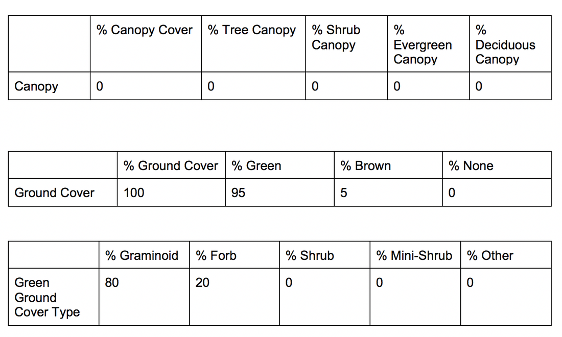 Discussion
This type of research provides us with both qualitative and quantitative observations about land use and cover change to compare to historical data. This data is imperative for observing trends over a period of time and aids in creating plans to combat those trends. More specifically, our data revealed no such trends. The absence of trends still provides useful information. Seeing that our data is concurrent with the photograph from 1939 demonstrates that the Estate Gardens have been maintained for the past 79 years and will continue to be for the foreseeable future. In manicured areas research such as ours is less descriptive of change than in residential or natural areas.
0 Comments
Leave a Reply. |
AuthorMason Kirkpatrick. Class of 2021 Archives
November 2018
Categories |
 RSS Feed
